Best Foot Forward: Norland to Ringstone Edge Moor


Beginning from Norland Moor; a place often passed through on many another passage; and indeed a place where a short stroll can be thoroughly enjoyed even if simply walking off the Sunday lunch; this ramble is just under eight miles long. It is easily navigable, with no major climbs or descents, and offers outstanding views all around. I arrived at the car park opposite the Moorcock Inn [GR SE 055 218] without a determined route; I simply felt like taking a walk in this area which I adore. I decided to aim towards Barkisland and Ringstone Edge reservoir; as having often driven past en route to Ripponden from the motorway bridge; I have always loved the beauty of this relatively small reservoir; always dramatically reflecting the skies above and the weather rolling in across the expanse of moorland all around.
I first walked up onto Norland Moor, taking the Calderdale Way heading right; a path new to me. This is a gorgeous pathway; with many benches situated to offer the loveliest of views, many commemorative of all the people who have previously enjoyed this vista. The Way descends to meet the road, where turning left, walk a short distance until turning right, down a driveway; still following the Calderdale Way. Passing farmhouses, you will then turn left, onto Moor Bottom Road; initially a grassy pathway, turning into a tarmac track. You will re-join the main road; just above the Fleece Countryside Inn. Turning left; take the road towards Barkisland, before turning right onto Rishworth Road. Continue along this quiet road; looking to the right you will see the dam of Baitings Reservoir in the distance. At the junction meeting the B6114, follow the Bridleway opposite towards Krumlin Hall [as marked on map] but actually passing a property called Knoll Top. Again, meeting a tarmac road, turn right, passing a collection of relatively newly built and rather grand looking houses in a cul-de- sac called Ringstone. Passing the phone box, the road begins to curve right as the motorway comes into view up ahead. If you were perhaps 10 metres higher, you would see Scammonden Water. The road turns right; you aim towards the dome-roofed tower that are so common to reservoirs [but what they are called I do not know!].
Advertisement
Hide AdAdvertisement
Hide AdAt Ringstone Edge Reservoir, turn left at the road junction, continue along Withens Lane, following a way marker citing the West Yorkshire Cycle Route suggesting Mytholmroyd only 13 miles away! At the dam; turn right descending along a track beneath the reservoir. Again the motorway comes into view on the distant hills; it’s like watching a steady flow of metallic ants snaking across the earthy brown moorland. There is the sound of fast flowing water in the deep gully to the left of you [Butts Clough] and ahead is an isolated white house. At the house, the path splits; take the upper path through a metal gate.
As you follow the path around the curve of the hillside, Ryburn Reservoir appears in view; which corrected my initial thought that the previously seen dam [Baitings] was not actually Ryburn Reservoir; as I had supposed.
It was at this point that I heard anything other than complete peace and silence that had accompanied me to this point. The sounds of school playgrounds drifted up from Rishworth beneath; the gentle whirring of motorway traffic also came within earshot. Passing underneath the electricity pylons; I simply lost the path; having to hop over a wall; despite what the map shows. On joining the tarmac track; turn right and enter woodland. You will emerge thinking
you’ve intruded onto private land; but there is a bridleway marker up ahead. Follow the bridleway, it bends quite distinctly before heading directly uphill. At a field boundary, turn left and follow that wall towards the transmitter mast up on the hillside. You approach some far buildings and the path meets Gosling Lane, which you then follow back up to meet the Saddleworth Road, which you’ll recognise from earlier.
Advertisement
Hide AdAdvertisement
Hide AdTurn left and just opposite the bridleway you followed earlier en route, there is a left hand, way-marked path and a sign reading ‘Upper Coneygarth’. It is an enchanting path; passing above a dell full of trees before meeting a track that leads back to meet Fiddle Lane. Turn left, descend slightly and you’ll meet the main road above Ripponden.
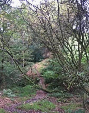
Turn right and head uphill, once again past The Fleece and back along Moor Bottom Road. At the next path junction, turn right uphill, but then take the left-hand way-marked path reading ‘Longley’ [alternatively you could continue uphill to retrace the beginning of the walk]. This last path was my favourite; a beautiful, magical route through a woodland del, crossing a stream over a stone footbridge. Be aware; the path appears to split, and I took the upper path, which turned out not to be a path, however I could scramble to re-join the main route.
Leaving the woodland over what looks to be a brand-new stile, probably installed by countryside volunteer groups such as CROWS, follow the field edge towards the buildings and road above. On meeting the road; you will turn left and it is a clear, short distance back to the start, passing Longley House, once Halifax Childrens’ Holiday Home.