Best Foot Forward: Into Calderdale from Scammonden Reservoir


Sitting next to the M62 is Scammonden Reservoir, built in conjunction with the motorway itself, involving the submersion of the nearby Deanhead village in the 1960s from where this walk begins. At 6.5 miles long; this is a technically challenging and quite demanding walk; taking you into South Calderdale, towards Ripponden, then back across the moorland and returning via a beautiful valley. I would not recommend this route for beginners; you do need to be conversant with a map; as quite a few of the paths are not clear; appearing un-used and at least for the first third, not way-marked. I’d certainly choose a dry day in the summer months for this walk!
Beginning from Wood Edge car park at Scammonden [GR SE 055 162, nearest postcode HD3 3FR], walk towards the motorway, then descend left, before taking the way-marked Cycle Route 68. You will cross the reservoir dam mirroring the motorway and on the far side, take the tunnel underneath the M62. Emerging the other side, ascend to your left, reaching Lower Road. Continue ahead, taking Pill Box lane, reaching a bus stop. Here turn left and you’ll see some boulders guarding the entrance to a wide path. Taking this track, you’ll pass a sign indicating a 1718-mile-long circular path; to which it refers I do not know. When the path splits, bear right, aiming for a ladder-stile and way-marker. You’ll descend to cross a catchwater [stream] and here there is a loose barbed wire fence; despite being a right of way. You can carefully lift the wire to climb through. Descend diagonally to your right, aiming towards the track and then walking to meet Withens End Lane as it turns. Go left, and shortly afterwards, on the right, there appears a private driveway, but it is a path that goes through Near Royd Farm and beyond to Farm Royd Farm. Reaching the second farm, there is a makeshift stile; climb over and continue in the same direction as before, aiming for a stile on the far side of the field. Here we were approached by an extraordinarily friendly sheep, who let us tickle it!
Advertisement
Hide AdAdvertisement
Hide AdYou’ll reach Cock Pit Lane where you turn left to descend. The path reaches a bend, here there is another stile with a sign indicating cattle in the field, plus a bench. Hop over the stile and begin a steep descent, initially through gorse and heather, before it becomes deep grass. A walking pole is useful here, simply to feel for where to put your feet.
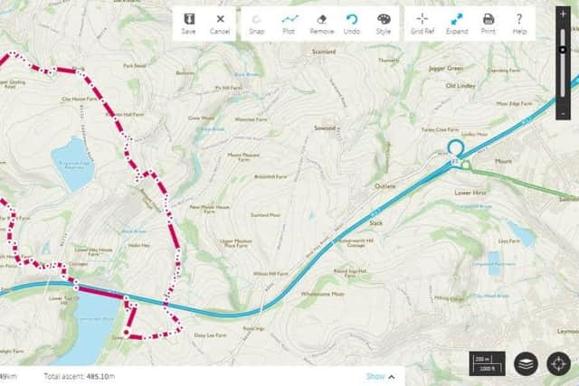
Not a frequently used pathway! At the very bottom, the path turns left where there’s a single house, Spread Eagle Cottage, and you feel you are trespassing as you cross the stile; we confirmed it was a path with the resident who kindly moved their washing aside on the line to let us pass! Reaching the tarmac road [GR SE 039 179], immediately turn right back on yourself down to cross a ford, then turn left, following Heys Lane, towards Ripponden. Reaching a bridleway, descend left to follow it. This walk could begin from Ripponden, and you could join this bridleway from the village at GR SE 043 194 . The bridleway climbs back up past Height Green and several houses. Turn left on reaching the road at the top, and just after the road bends there is a narrow, overgrown, but way-marked, corridor which enters woodland where you turn left and take the lower path alongside a field edge. Here we saw a wild deer, the first of which I’ve seen in Calderdale. You’ll eventually turn left to make a short climb up to another narrow track; turning right [GR SE 047 192] to climb until you meet a driveway which leads to Rishworth Road. Almost directly ahead there is another bridleway, which crosses the brow of the hill, and passes Krumlin Hall [marked on map] which
now seems to be called Knoll Top. This track is much kinder underfoot, a welcome respite!
Crossing a road, take another overgrown path directly ahead, emerging at New Laithe. Here I was forced to change my planned route due to the paths being both blocked and so overgrown they were impassable. Therefore, I followed the road to the right, then left, shortly afterwards taking a track on the left [GR SE 056 182]. This appears to be another driveway and you pass a property, passing through a metal gate; [don’t be confused by a painted yellow arrow pointing right] and then reaching another track. Turn left, pass Banquet House, and just before Firth House, take the path way-marked to your right [GR SE 058 180]. A descent through woodland emerging into a field, continue downhill until the field boundary at the woodland edge. There is a way-marker pointing left and right, go right, through the pretty undergrowth, descending to the houses at the bottom, crossing a footbridge and meeting a tarmac road; Hey Lane. From here it is much easier; simply follow Hey Lane back towards the motorway. You’ll pass underneath it and despite a way-marker and the map suggesting a path immediately afterwards; there appeared no path, so instead we walked up to meet Chapel Hill Lane [GR SE 062 163], turning right, walking up Green Slacks Lane where soon the car park, much to our relief, came into sight!
Advertisement
Hide AdAdvertisement
Hide AdAn equally demanding and rewarding walk; and if making the trip to begin at Scammonden, the nearby village of Slaithwaite is a vibrant place full of charming eateries and pubs in which you can satisfy an understandable appetite!