Best Foot Forward: Exploring Cragg Vale


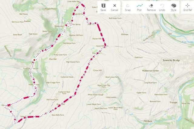
Cragg Vale, is perhaps my favourite part of Calderdale. This 7.5-mile walk takes you through all the varied topography of the area – open moorland, valley bottoms and woodland. With beautiful views throughout; it is well way marked, overall, but, despite it being summer, I’d certainly recommend walking shoes as opposed the sandals I wore for this route!
Beginning from Cragg Vale, there is road parking near to the Hinchcliffe Arms HX7 5TA, GR SD 999 232. You can begin from the car park at Withens Clough Reservoir, crossing the dam and joining the permissive path; however, the day I walked, the road was closed! Therefore, we began by taking a path way-marked “Higher House Moor”. This track climbs through dappled sunlight filtering through the trees that line it; with foxgloves growing from the walls. It gets a little steeper and you pass over a stream, approaching Higher House Barn at the top, where the path passes through a gate and is kindly signposted by the home-owner.
Advertisement
Hide AdAdvertisement
Hide AdBeyond the house, you meet the moorland edge. There are way-markers indicating paths to the left and right, however, you will spot a trodden path going almost immediately ahead of you, climbing towards a boulder sitting on the horizon. There is a trace of a path through the undergrowth; less clear as you get further onto the moor but soon enough you’ll spot an isolated building, marked on the map as Shooting Box; restored in recent years by Yorkshire Water. Aim in that direction, beware the path may get boggy underfoot.
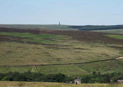
The map indicates that the path curves around the back of the building, and you do indeed pass behind it, however, instead of venturing into the bracken and heather as I did in search of the path, literally go right around the building and a path has been made that is clearer. Essentially you are aiming for what look like crumbling chimney remains; there are a line of them, along which the path runs. These are Grouse Butts, from where grouse shooters take their shots. I found my walking pole very useful at this point of the ramble, simply to decide where to put my feet and where not! The moorland surrounding Cragg Vale are peat moors which developed between 5000-3000 BC as climate change caused the soil to deteriorate, washing away minerals and plant life, however evidence has been found of long distance trade and movement of people in this area, as well as woodland being present on the moor further back in the past, approx. 10,000 BC.
Ahead you will see a farmhouse on the opposite valley slope, with a clear road descending to the right. The path will curve around the hillside to meet the bottom of this road at a footbridge, where you cross, turn left and climb the tarmac lane, reaching the main road. Continue ahead onto Sykes Gate and proceed until Sykes Farm [SE 003 216], where you pass through a gate on your right, curve left and follow the edge of woodland, bearing north-east.
Keep going in the same direction until meeting another gate and the Calderdale Way. Turn left and go straight ahead, following Water Stalls Road. Turn right on meeting High Stones Road, pass Pitts Farm and after the campsite, turn left onto a clear, gravelled track – a way-marked bridleway. After approx. 800m you meet a boundary, turn left here, towards the quarries [SE 019 244]. Pass the quarries and curve around to the right underneath them. On the turn, there’s an immediate path to the left, pass this, taking the second left, a walled passageway across a field, passing through a cross roads, then turning left to follow the path, which becomes a driveway. You walk through this property’s garden and spot a way-marker through a gate beyond a small lawn. Up ahead you see the woodland, and
Advertisement
Hide AdAdvertisement
Hide Adyou will cross a stile to turn left at the bottom of the field to walk along the top edge of the woodland – a bit of shade a pleasant relief on particularly hot days! The path continues along the top edge for 0.5km before descending right. Shortly after, there is a path cross-road [SE 010 242] – turn right and begin the zig-zag descent through the woodland. As with all woodlands, some paths are less clear, but, having become lost myself, I chose a route far easier to follow! Therefore, at the first opportunity [way-marked] turn left [SE 010 244]. Here there are some walls that are marked on the map in vaguely rectangular shapes. Continue to follow the path down, meeting a boundary wall at the bottom and follow this until you emerge from the trees into a collection of cottages – Twist Clough.
Turn right to descend to the road at a bus stop, where you turn left, walk awhile along the pavement before the opportunity on the right to turn onto Castle Gate – a long lane that passes houses above the river until reaching a bridge. Here, leave the lane and enter the field, following the clear path across the meadow towards the church – St John the Baptist in the Wilderness, built in 1815. You’ll return to the start where a refreshing pint was deserved [and enjoyed!] by myself and my husband at the Hinchcliffe Arms on a particularly gorgeous, sunny afternoon.